GPS Grid Reference - Full APK
最新版本
6.1.4 for Windows
更新
2016年March07日
信息
版 6.1.4 (#1)
更新 2016年March07日
APK檔案大小 5.7 MB
Android 最低版本需求 Android 2.3+ (Gingerbread)
開發人員 Luck
類別 旅遊與地方資訊 (應用)
應用 ID com.luck.GgridReference
開發者備註 GPS, Waypoints and Offline map features! + Android Wear support
螢幕截圖圖片
點擊圖像以查看完整尺寸


最新異動
GPS Grid Reference - Full 6.1.4的新功能
- More fix for OS grid shifting in Manage Waypoints
內容描述
Great app for outdoor sports, running, hiking, site survey, search & rescue, travel, landnav training and more!! Suitable for all devices and tablets!
Now with Android Wear support, giving important information on your wrist.
User testimonial:
"Brilliant App for Military & Emergency Personnel With support for most major grid reference systems, a built-in compass and My Tracks integration, this application is perfect for military or emergency personnel, in addition to anyone whom spends large amounts of time hiking, bush-walking, etc... Extremely accurate and quick to lock-in a location by satellite"
Why not try out the free demo first?
Many GPS & Compass features, combines with various OFFLINE maps (UK OS map, USGS, OSM, Mapnik, Topo & Cycle and more!).
Support GPX (GPS Exchange Format) file import. Simply use any file manager and select a GPX file to import.
Supported coordinates: OS grid reference, Tetrad, MGRS (WGS84), MGRS (WGS84), MGRS(NAD27), WGS84, OSGB86, Maidenhead, DMS, UTM, USNG and CH1903 Swiss Grid.
- LiveView support - display coordinate information, satellite information, ETA and time information.
- SE LiveView Beta (display coordinate information (right menu), satellite information (left menu), ETA (down menu) and time information (up menu). Any problems please email info@gpsgridreference.com.
* Track Recording via My Tracks. Record your tracks, see live stats export tracks and share with friends via Google or GPX, KML, CSV and TCX file.
** Visit website www.gpsgridreference.com, checkout full user guide and videos **
**Any issues or feature requests please email me**
GPS mode shows coordinates from GPS, offline maps with switchable full screen mode, compass, GPS status and overlay the waypoints over the maps to get distance, bearing and ETA.
GPS mode now equipped dual screen (just swipe top screen) with digital compass and mils, ETA time and minutes, sunrise and sunset time
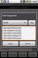
Manage waypoints mode allows you to create set of waypoints, using maps or manually enter coordinates and use it in GPS mode.
Get Coordinate from Map mode; simple way to get and share various types of coordinates from maps
Compass mode show analogue and digital mode with mils.
Search address for spatial information mode provides ability to search and obtain coordinates for any address and postcode anywhere in the world.
extends:com.sonyericsson.extras.liveview
Smart Connect extension for SmartWatch 2
Now with Android Wear support, giving important information on your wrist.
User testimonial:
"Brilliant App for Military & Emergency Personnel With support for most major grid reference systems, a built-in compass and My Tracks integration, this application is perfect for military or emergency personnel, in addition to anyone whom spends large amounts of time hiking, bush-walking, etc... Extremely accurate and quick to lock-in a location by satellite"
Why not try out the free demo first?
Many GPS & Compass features, combines with various OFFLINE maps (UK OS map, USGS, OSM, Mapnik, Topo & Cycle and more!).
Support GPX (GPS Exchange Format) file import. Simply use any file manager and select a GPX file to import.
Supported coordinates: OS grid reference, Tetrad, MGRS (WGS84), MGRS (WGS84), MGRS(NAD27), WGS84, OSGB86, Maidenhead, DMS, UTM, USNG and CH1903 Swiss Grid.
- LiveView support - display coordinate information, satellite information, ETA and time information.
- SE LiveView Beta (display coordinate information (right menu), satellite information (left menu), ETA (down menu) and time information (up menu). Any problems please email info@gpsgridreference.com.
* Track Recording via My Tracks. Record your tracks, see live stats export tracks and share with friends via Google or GPX, KML, CSV and TCX file.
** Visit website www.gpsgridreference.com, checkout full user guide and videos **
**Any issues or feature requests please email me**
GPS mode shows coordinates from GPS, offline maps with switchable full screen mode, compass, GPS status and overlay the waypoints over the maps to get distance, bearing and ETA.
GPS mode now equipped dual screen (just swipe top screen) with digital compass and mils, ETA time and minutes, sunrise and sunset time
Manage waypoints mode allows you to create set of waypoints, using maps or manually enter coordinates and use it in GPS mode.
Get Coordinate from Map mode; simple way to get and share various types of coordinates from maps
Compass mode show analogue and digital mode with mils.
Search address for spatial information mode provides ability to search and obtain coordinates for any address and postcode anywhere in the world.
extends:com.sonyericsson.extras.liveview
Smart Connect extension for SmartWatch 2
評分和評論
評分:4.3 / 5 · 4+ 票
(*) 是必須的
之前的版本
GPS Grid Reference - Full 6.1.4 APK - 下載 適用于 Windows - (#1, 5.7 MB)