gps corresponding Tokyo risk map APK
最新版本
1.0 for Windows
更新
2012年August28日
信息
版 1.0 (#1)
更新 2012年August28日
APK檔案大小 42.9 MB
Android 最低版本需求 Android 2.3+ (Gingerbread)
開發人員 Asahi Press
類別 生活品味 (應用)
應用 ID com.indieweb.tokyokikendomap
開發者備註 ◆ go home route, family peace of mind, this product for the emergency contact is, "Tokyo Metropolitan Urban Development Bureau" and "Tokyo Fire Department" anti-earthquake measures guide the definitive edition made with the cooperation of "large earthquak
螢幕截圖圖片
點擊圖像以查看完整尺寸


內容描述
◆ go home route, family peace of mind, this product for the emergency contact is, "Tokyo Metropolitan Urban Development Bureau" and "Tokyo Fire Department" anti-earthquake measures guide the definitive edition made with the cooperation of "large earthquake Tokyo danger of your town
It is an app version of the degree map ".
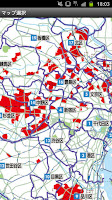
■ The main function (1) fire risk and building collapse risk route search function can be seen (2) emergency mail transmission at the time of emergency (3) If the provided "major earthquake completely countermeasures manual" and disaster prevention Book ■ fire danger
de collapse route search function this map that risk is understood, when that happened is a large-scale earthquake in Tokyo, on the basis of a high risk area of the building collapse, the danger areas of high fire to the Tokyo survey data, town
It shows in another color and pattern for each chome.
- You are here of the risk are the confirmation now location using the gps function is displayed on the map, you can see the risk of the area around the current position immediately.
(Off-line map that can be confirmed in a mobile out of range of circumstances also available), route search departure and destination points from the starting point to the destination is selected in the "You are here", "character input", "Address List selection (ward → town →-chome
) "can be entered in.
※ There is no voice guidance function.
※ route that is displayed does not take into account the risk enough.
Please move in safety first to determine the actual road conditions, the disaster situation.
■ emergency mail transmission emergency at the time of emergency, you can deliver emergency messages when in crisis situations.
Mail: If you press the button, the location (current location information) are the message now registered in advance, and then delivered to the other party registered.
Subscribe destination, you can address registered up to 10 people.
It can be configured to simultaneously delivered.
· Twitter, facebook: When you press the emergency mail button, the location (current position information) are the message now that you pre-registered, and delivers it to the logged-in account.
■ equipped to if "major earthquake completely countermeasures manual", disaster prevention, Book-Tama area - Tama area map, contact details relating to disaster prevention of each municipality, is forecast Figure-large damage Evacuation Area Tokyo of ground and liquefaction is expected
wooden houses dense area and a large earthquake completely measures manual - in order to protect themselves from the earthquake (Tokyo Fire Department) - dwelling building protect themselves that can be safety of Knowing / advance only at the time of the earthquake - "earthquake at that time by the Tokyo Fire Department
10 points "and large earthquake protect the lives, if there an earthquake in addition to wide area refuge, home to protect the life from the emergency deal with law and the whole family of disaster prevention check and disaster prevention Book of -" window on seismic Evaluation and renovation, "" Tokyo of disaster prevention
learning and experience facilities "" in this book about how to contact list ■ map of Tokyo of disaster management agencies "may," regional risk measurement survey on earthquake
Tsugesho among the (6th) "(Tokyo Urban Development Bureau / February 2008 issue), the local regional risk falls on 5 stages in 4 and 5 as" high risk area ", Tokyo
When the building collapse risk of the Tama area, has been shown in the map with a high fire risk area by color and pattern.
In the mapping of the book, with the approval of the Geographical Survey director, it was used 25,000 parts per topographic map of ministry issued (approval number flat 23 boss, No. 293-28127) Hokkaido map, Inc. created
of using the gismap.
※ map data has been taken from was published in March 2012, "Tokyo risk map of a large earthquake in your town."
■ Notes - Compatible models: Android 2.2 or higher.
- at the time of installation requires free space of about 150mb.
· There is no navigation and voice guidance function in this application.
Please move in safety first in consideration of the actual road conditions, the disaster situation searched route.
During your use of this application, even in a case that caused the accident, we do not take any responsibility.
And information that is provided in this app, does not guarantee always Yomiuri Shimbun that it is the latest and accurate and complete.
Is when you use, please handling as reference information.
• When you use of this application, such as a link click of the online map · SOS transmission and reserve list, you will need an Internet connection by 3g line or the like.
It is recommended that you wish to use to join the packet flat-rate full.
In the route search of the place of departure, destination setting, you may not be able to set about the part of the address.
It is an app version of the degree map ".
■ The main function (1) fire risk and building collapse risk route search function can be seen (2) emergency mail transmission at the time of emergency (3) If the provided "major earthquake completely countermeasures manual" and disaster prevention Book ■ fire danger
de collapse route search function this map that risk is understood, when that happened is a large-scale earthquake in Tokyo, on the basis of a high risk area of the building collapse, the danger areas of high fire to the Tokyo survey data, town
It shows in another color and pattern for each chome.
- You are here of the risk are the confirmation now location using the gps function is displayed on the map, you can see the risk of the area around the current position immediately.
(Off-line map that can be confirmed in a mobile out of range of circumstances also available), route search departure and destination points from the starting point to the destination is selected in the "You are here", "character input", "Address List selection (ward → town →-chome
) "can be entered in.
※ There is no voice guidance function.
※ route that is displayed does not take into account the risk enough.
Please move in safety first to determine the actual road conditions, the disaster situation.
■ emergency mail transmission emergency at the time of emergency, you can deliver emergency messages when in crisis situations.
Mail: If you press the button, the location (current location information) are the message now registered in advance, and then delivered to the other party registered.
Subscribe destination, you can address registered up to 10 people.
It can be configured to simultaneously delivered.
· Twitter, facebook: When you press the emergency mail button, the location (current position information) are the message now that you pre-registered, and delivers it to the logged-in account.
■ equipped to if "major earthquake completely countermeasures manual", disaster prevention, Book-Tama area - Tama area map, contact details relating to disaster prevention of each municipality, is forecast Figure-large damage Evacuation Area Tokyo of ground and liquefaction is expected
wooden houses dense area and a large earthquake completely measures manual - in order to protect themselves from the earthquake (Tokyo Fire Department) - dwelling building protect themselves that can be safety of Knowing / advance only at the time of the earthquake - "earthquake at that time by the Tokyo Fire Department
10 points "and large earthquake protect the lives, if there an earthquake in addition to wide area refuge, home to protect the life from the emergency deal with law and the whole family of disaster prevention check and disaster prevention Book of -" window on seismic Evaluation and renovation, "" Tokyo of disaster prevention
learning and experience facilities "" in this book about how to contact list ■ map of Tokyo of disaster management agencies "may," regional risk measurement survey on earthquake
Tsugesho among the (6th) "(Tokyo Urban Development Bureau / February 2008 issue), the local regional risk falls on 5 stages in 4 and 5 as" high risk area ", Tokyo
When the building collapse risk of the Tama area, has been shown in the map with a high fire risk area by color and pattern.
In the mapping of the book, with the approval of the Geographical Survey director, it was used 25,000 parts per topographic map of ministry issued (approval number flat 23 boss, No. 293-28127) Hokkaido map, Inc. created
of using the gismap.
※ map data has been taken from was published in March 2012, "Tokyo risk map of a large earthquake in your town."
■ Notes - Compatible models: Android 2.2 or higher.
- at the time of installation requires free space of about 150mb.
· There is no navigation and voice guidance function in this application.
Please move in safety first in consideration of the actual road conditions, the disaster situation searched route.
During your use of this application, even in a case that caused the accident, we do not take any responsibility.
And information that is provided in this app, does not guarantee always Yomiuri Shimbun that it is the latest and accurate and complete.
Is when you use, please handling as reference information.
• When you use of this application, such as a link click of the online map · SOS transmission and reserve list, you will need an Internet connection by 3g line or the like.
It is recommended that you wish to use to join the packet flat-rate full.
In the route search of the place of departure, destination setting, you may not be able to set about the part of the address.
評分和評論
評分:5.0 / 5 · Less than 100 票
(*) 是必須的
之前的版本
gps corresponding Tokyo risk map 1.0 APK - 下載 適用于 Windows - (#1, 42.9 MB)