Geo-Wiki Pictures APK
最新版本
4.0.2 for Windows
更新
2017年June29日
信息
版 4.0.2 (#29)
更新 2017年June29日
APK檔案大小 5.7 MB
Android 最低版本需求 Android 4.1+ (Jelly Bean)
開發人員 IIASA Apps
類別 攝影 (應用)
應用 ID GeoWikiMobile.GeoWikiMobile
開發者備註 Photograph landscapes and share your photos with friends through Geo-Wiki.org
螢幕截圖圖片
點擊圖像以查看完整尺寸


內容描述
With the Geo-wiki pictures app, you can photograph landscapes and share your photos with friends and colleagues through Geo-Wiki.org, a visualization and crowdsourcing tool developed by IIASA for improving global land cover maps. Global land cover maps are used in a number of environmental applications including assessment of the effects of climate change, deforestation and impacts on biodiversity. Your photographs can help us to improve the quality and the validity of these land cover maps. The Pictures Geo-Wiki mobile app will automatically geo-reference your photos and tag them with information such as the compass direction and the angle of tilt along with the land cover type and other any other comments that you wish to add.
Features:
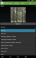
1. Take photographs of landscapes while on holiday or while out with your friends, which automatically adds a geographic coordinate, the compass direction and the angle of tilt to each photo.
2. Tag the photographs with any additional comments or text.
3. Tag the photographs with a land cover type based on a simple to use drop down menu. These land cover types are used to help us validate global land cover maps.
4. Upload these photos to Geo-Wiki.org, a site that allows you to visualize your photographs on Google Earth. The images can be uploaded via mobile connection or stored until you have Wi-Fi access.
The screenshots displayed here include imagery used under Creative Commons Attribution-Share Alike 2.0 Generic license from following copyright holders:
-Forest (Pinus palustris) by Sue Waters (http://www.flickr.com/photos/suewaters/)
-Grassland (Mongolian-Manchurian grassland) by Shizhao (http://commons.wikimedia.org/wiki/User:Shizhao)
Features:
1. Take photographs of landscapes while on holiday or while out with your friends, which automatically adds a geographic coordinate, the compass direction and the angle of tilt to each photo.
2. Tag the photographs with any additional comments or text.
3. Tag the photographs with a land cover type based on a simple to use drop down menu. These land cover types are used to help us validate global land cover maps.
4. Upload these photos to Geo-Wiki.org, a site that allows you to visualize your photographs on Google Earth. The images can be uploaded via mobile connection or stored until you have Wi-Fi access.
The screenshots displayed here include imagery used under Creative Commons Attribution-Share Alike 2.0 Generic license from following copyright holders:
-Forest (Pinus palustris) by Sue Waters (http://www.flickr.com/photos/suewaters/)
-Grassland (Mongolian-Manchurian grassland) by Shizhao (http://commons.wikimedia.org/wiki/User:Shizhao)
評分和評論
評分:3.3 / 5 · Less than 100 票
(*) 是必須的
之前的版本
Geo-Wiki Pictures 4.0.2 APK - 下載 適用于 Windows - (#29, 5.7 MB)