Canada Topo Maps Pro APK
App information
Version 5.1.3 (#1)
Updated 2021-05-29
APK Size 1 MB
Requires Android Android 2.3+ (Gingerbread)
Offered by ATLOGIS Geoinformatics GmbH & Co. KG
Category Free Maps & Navigation App
App id com.atlogis.camaps
Developer's notes Topographic Maps 1:50.000 of Canada
Screenshot
Click on the image to see full size
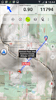
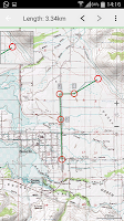
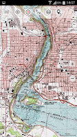
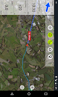
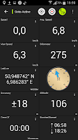
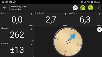
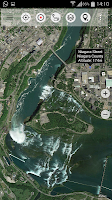
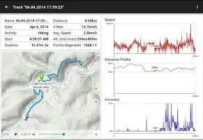
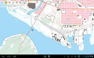
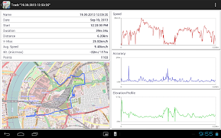
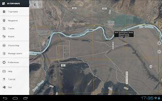
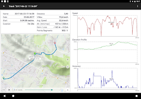
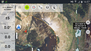
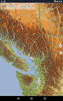
Table of contents
Latest updates
What's new in Canada Topo Maps Pro 5.1.3
• Improvements & Fixes
Editor's review
Download the latest Canada Topo Maps Pro application, version 5.1.3, compatible with Windows 10/11 (using emulators such as Bluestacks), Android devices. This free Maps & Navigation app is developed by ATLOGIS Geoinformatics GmbH & Co. KG and is easy to download and install.
Previous versions, including 5.1.3, are also available. If you need help or have any problems, please let us know.
Description
This app gives you similar mapping options as you might know from Garmin or Magellan GPS handhelds.
*** Attention: Please use Toporama or Canada Base Map layer if you need most recent topo maps ! ***
Main features for outdoor-navigation:
• Bulk-download of map tiles for OFFLINE USAGE (not for Google and Bing maps)
• Create and edit Waypoints
• GoTo-Waypoint-Navigation
• Create and edit Routes
• Route-Navigation (Point-to-Point Navigation)
• Track Recording (with speed, elevation and accuracy profile)
• Tripmaster with fields for odometer, average speed, bearing, elevation, etc.
• GPX-Import / Export, KML-Export
• Search (placenames, POIs, streets)
• Customizable datafields in Map View and Tripmaster (e.g. Speed, Distance, Compass, ...)
• Share Waypoints, Tracks or Routes (via eMail, Facebook, ..)
• Use Coordinates in UTM, WGS84 or MGRS
• and many more ...
Available map layers:
• Topomaps Canada (CanMatrix, seamless coverage at scales 1:50.000 and 1:250.000)
• Toporama Maps Canada (CanVec, NTDB, Atlas of Canada)
• Canada Basemap (CanVec, NTDB, Atlas of Canada)
• CanTopo (new Canada topos at 1:50.000, partial coverage of Can)
• Google Maps (Satellite images, Road- and Terrain-Map)
• Bing Maps (Satellite images, Road-Map)
• Open Street Maps (OSM Mapnik and Cloudemade Cyclemap)
• Hillshading overlay layer for OSM, Google, Bing or Toporama maps
Toporama Maps Canada: These are the most recent topographic maps of Canada. Can be enhanced with hillshading overlay.
Topomaps Canada: These maps contain many small pathes and 4WD tracks that are missing in Toporama, Google, Bing and OSM maps. This layer is essential for real outdoor and offroad trips in Canada. Seamless mosaic of more than 13.000 collar clipped 1:50.000 maps.
Use this navigation app for outdoor activities like hiking, biking, camping, climbing, riding, skiing, canoeing or offroad 4WD tours.
Preload FREE map data for areas without cell service.
Canadian topographic maps are enhanced with Atlogis® hillshading and placenames.
Credits for topographic map data: "© Department of Natural Resources Canada. All rights reserved."
Please send comments and feature requests to canadamaps@atlogis.com
Ratings and Reviews
Rating: 4.4/5 based on 10+ reviews
(*) is required
5 ★ I've been using this app for years. I map my skidoo and off road motorcycle tracks with it and use it a lot to explore topo maps and aerial imagery for planning trips. A number of my friends use this app as well. If you are going to have just one app for mapping and navigation this is the one.
4 ★ Its a good app does what I want. But sometimes when I'm out of service it has a hard time loading the map around my location. I need to zoom out and back in to try and get it to focus. Other then that it works good with tracking roots and marking point.
5 ★ I was using this app for years. I off road alot in my Jeep and it comes handy when making plans. I use Toronto overlays.Very good. Minor "updates"/accuracy discrepancies, but most likely due to some trails, especially logging places, get overgrown or newly developed. Good elevation grids and it comes handy when cross reference with other maps and when knowing your elevation
5 ★ Have gotten lots of use out of this app. Been very reliable and easy to use. Despite the name it also worked great in Europe when I had a chance to do some hoking there.
4 ★ Worth the money, great tool for orientation and tracking if you do any kind of work in forestry. Just wish it had a more recent satellite image/map ( ESRI Aerial ) for work purpose. Sometimes recent logging roads, cut blocks are not shown, map/image is probably from around 2015.
4 ★ Worth the money, app is great i just wish there was an auto cache feature so I didn't have to download such massive areas for trips.
4 ★ Can't get enough of this app. Great for hikers and trail trackers. Worth buying pro, not that you really have to.
3 ★ It work for years now I got a samung s10 and now it will stop recording please help it was was my best app for recording my hikes atv atv rides
1 ★ Used to be a solid 4 stars, now it doesn't work at all. Sooo glad I paid foe this piece of garbage.
5 ★ I've been using these maps for several years. Lots options to choose from. The one thing I would like to see added is maps of government/crown land.
5 ★ Straight up, the best program you could download for GPS mapping, plotting trails and documenting locations visited. Well worth every penny.
5 ★ Have been using free version for years. I needed to import GPA tracks. Should have done it sooner. Seamless import
4 ★ Great maps lots of detail but the arrow that shows where your pointing isn't very accurate.
5 ★ Great app. Nothing fancy, but displays and downloads Canadian topo maps quickly, creatures tracks easily. No hidden charges.
5 ★ A must for all explorers, urban, rural and wild. Love this software!
Previous versions
Similar to Canada Topo Maps Pro
More from ATLOGIS Geoinformatics GmbH & Co. KG
Top download apps
Resso Music - Songs & Lyrics APK