Walk Colwall - Ledbury APK
App information
Version 1.2 (#1002000)
Updated 2013-12-20
APK Size 49.8 MB
Requires Android Android 2.2+ (Froyo)
Offered by BrooksDesigns
Category Free Travel & Local App
App id air.uk.co.brooksdesigns.GeoparkColwall
Developer's notes Explore the deep time history of the rocks beneath as you walk the Geopark Way
Screenshot
Click on the image to see full size


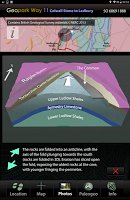


Table of contents
Editor's review
Download the latest Walk Colwall - Ledbury application, version 1.2, compatible with Windows 10/11 (using emulators such as Bluestacks), Android devices. This free Travel & Local app is developed by BrooksDesigns and is easy to download and install.
Previous versions, including 1.2, are also available. If you need help or have any problems, please let us know.
Description
All revenue from the sale of the app is donated to the Geology Trusts who have created and maintain this walk.
From Colwall Stone railway station the path runs along a ridge of Silurian rocks then drops down through the pretty hamlet of Evendine onto the flat Raglan Mudstone plane in the Colwall Green area - crossing the bed of a former glacial meltwater lake. Continuing through the village of Colwall, open fields and apple orchards, the path eventually climbs back onto Silurian rocks, whose alternating hard limestones and softer shales gives classic ridge and vale topography, to reach Oyster Hill and offer panoramic views. Widing back down to the village of Wellington Heath, passing an exposed anticline, into Frith Wood and from their to the historic market town of Ledbury.
The app has 5 core views, the default is the Map of the trail, overlain on a geology map derived from the British Geological Survey DiGMapGB-50 (1:50,000 scale) data for the Colwall Stone to Ledbury area. You have this map built into the app, along with all the associated BGS data, which is then always available as you walk, served to your position by GPS or, by simply touching the map if using the app away from the area, or on a device without GPS. The map can be zoomed to x4.
The Photos view contains a series of pictures taken along the walk, from the perspective of someone walking in either direction – you select which direction to view. When you use the app in the area, images and information relevant to your location are served to you. You can also virtually walk the path – perhaps to get a feel in advance of how challenging the terrain will be. Linked to the Photos view are 3D sections of the geology and reconstructions of ancient environments.
The Location view provides position data and optionally will record your walk and provide an updated estimate of how long to it will take you to complete.
The Information view provides links to the organisations, including the Herefordshire and Worcestershire Earth Heritage Trust, who founded and continue to promote and manage the Geopark and the trail.
The app has all required data loaded and does not require cellular or WiFi connectivity in the field – just a charged battery.
The app contains a great deal of detailed visual data and is optimally used in the field on devices with screen sizes in the 5 to 7 inch range – larger tablet screens are great too, but can be tiring to hold for a long time and are less easily stored away in a pocket or backpack.
App permissions
Walk Colwall - Ledbury 1.2 APK requires following permissions:
Allows applications to open network sockets.
Allows an app to access precise location.
Allows an app to access approximate location.
Ratings and Reviews
Rating: 1.0/5 based on Less than 100 reviews
(*) is required
Previous versions
Walk Colwall - Ledbury 1.2 APK for Windows (#1002000, 49.8 MB)
Similar to Walk Colwall - Ledbury
Walk Bridgnorth - Dudmaston APK
Walk Minsterworth - Gloucester APK
Walk Huntley - Minsterworth APK
More from BrooksDesigns
Top download apps
فیلتر شکن جدید و قوی،فیلتر شکن قوی و پرسرعت رایگان APK